 |
Snowdonia CAPEL CURIG 05-11 June 2014 |
|
| Arrive Snowdon Swallow Falls Llyn Cowlyd Penrhyn Maps Goodbye Thanks * Please Note! * |
Our CLOG Visit to Capel Curig
One of the strong points of CLOG is that an away-break spawns many parallel activities with plenty of choice. Our Capel Curig visit certainly lived up to CLOG's time-honoured reputation! Of course, in these pages I focus on those activities in which I partook, or I had the opportunity to lead. Mount Snowdon (1035 metres) is a Welsh icon, so for many of us was a "must-do".
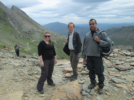
We have come up from Pen-y-Pas over the scenic Pyg Track, which you can see behind us. It's still a bit of a way up the final steep push to the summit of Snowdon.
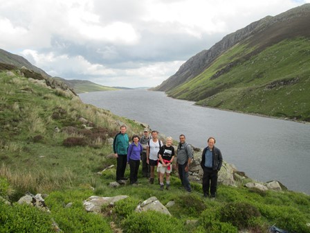
This a group picture of our Llyn Cowlyd walking party with, would you believe,
Llyn Cowlyd in the background.
For those who espouse a more poetic slant to life, I have appended some verse. However, this humble endeavour of mine should not be seen as any attempt to take the poetic world by storm! It is indeed just intended to be a bit of playful rough and ready verse!
|
It was for the mountains of North Wales that this time we "set our sails". Up iconic Mount Snowdon we went whilst to us the good weather was sent. Next day, of Swallow Falls and Ty Hyll was the talk as along Afon Llugwy's green valley we did our walk. Goodness, time flew and then already it was Sunday, destination Llyn Cowlyd and then a nice lakeside café. On Monday it would be more leisurely, we reckoned, when Penrhyn Castle and Bodnant Gardens to us beckoned. To Jim and Penny and to contributors our thanks do go, to event leaders and all who their enthusiasm now did show. |
What you will see here
I hope you enjoy reading and looking at these pages and that they will bring back memories of our recent trip. These pages may also provide an inspiration for future trips to Snowdonia, which I'm sure we would all like to make. In that case they will have fulfilled a further purpose. So, without further ado, let's relive some of our experiences!
- Arrival in Capel Curig ( Thursday )
- Snowdon ( Friday )
- The Ugly House, Miners' Bridge and Swallow Falls ( Saturday )
- Llyn Cowlyd & Llyn Crainant ( Sunday )
- Penrhyn Castle and Bodnant Gardens ( Monday )
- Goodbye Capel Curig ( Tuesday )
- Maps, Heights & Figures
- Track Files for our walks
- Thankyou!
- Spoken Narrative.
This is a 1½ minute audio presentation of our CLOG visit to Snowdonia. It should work with the three main browsers, but please click here if you would like more logistical details on this audio presentation.
- Contact, Copyright & "Readme" This gives more general considerations relating to this page and other pages on this web site.
- Helpful Extra Notes
Maps, Heights & Figures for Our Walks
Here you will see the maps, heights and other numerical items pertaining to our walks. In this section, the walks on June 6, 7 and 8, to Snowdon, the Miners' Bridge and Llyn Cowlyd are coloured blue, red and green respectively for ease of recognition. (Track Files for our walks). As always, please make allowances for the accuracy or otherwise of my map plotting (e.g. start and end elevations of our June 7 and 8 walks all should be the same, but are one metre out) and possibly of the - albeit very good - plotting tool which I use. However, at least you can see the overall gist of what we got up to!
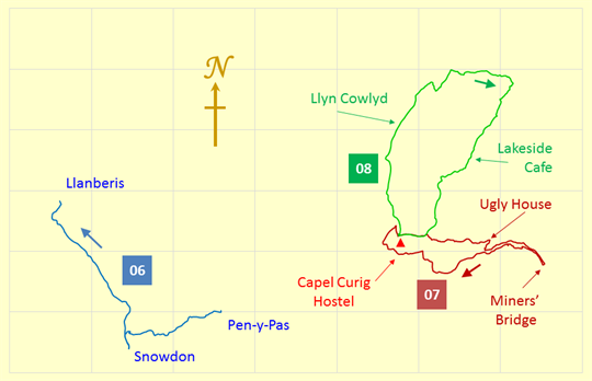
Here you can see three of our walks on successive days, on June 6, 7 and 8. In this "map" the distance scale for and between the three walks is the same. The red triangle indicates our hostel which is situated at the western junction between our red and green (June 7 and 8) walks.
The grid scales are: longitude -4.15° to -3.80° and latitude 53.06° to 53.18°.
These translate to 23.36 Km W to E and 13.34 Km S to N,
when using 6371.0 Km as the volumetric mean radius of the earth!
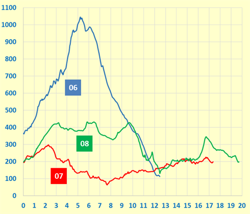
Here you can see the relative heights we reached on our three walks. The vertical (y-axis) scale is in metres and the horizontal (x-axis) scale is in Kilometres. As can be expected, the maximum height of our Snowdon walk dominates the heights reached on our other walks.
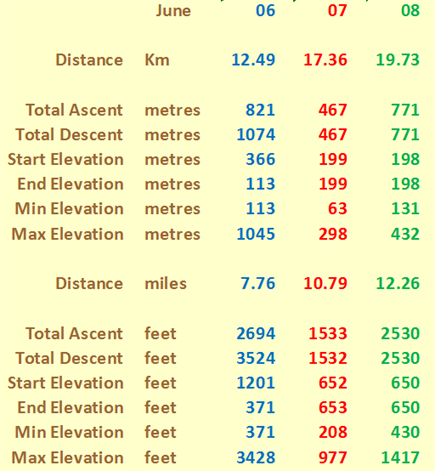
These might at first glance look like a mass of numbers. However, it's what we can read into them that I think is quite interesting. For example, our total ascent over the three consecutive days was just over two Kilometres, and the total mileage (as always, measured on a conceptual flat plane) was about 31 miles. Of course, in the mountains, total ascent vies with distance as an important consideration of personal physical achievements.
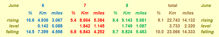
And here, for the numerical fun of it, are the gradients we overcame on each of our three walks, together with the resultant gradient over the three days.
Each of the gradients is averaged over the distance given, with level stretches having rises less than ± ½ metre. By comparison, Hertfordshire County Council recommends that its roads should not have longitudinal gradients of more than 5% and one of the steepest adhesion railways in the world, in Austria, has a maximum gradient of 11.6%.
Thank You!
Many Thanks to Jim and Penny who organised this CLOG away break. Unfortunately, for medical reasons, they could not participate in the fruit of their organisational endeavours. Thanks to all the walk and event organisers and to everyone for a great time!
Eric Scharf
Version: 2014-08-09 @21:05
Updated: 2014-09-30 @12:06 & 2014-10-25 @20:29
Updated: 2019-01-23 @18:42
SAGAX REX HANC RETIS ORBIS PAGINAM PINXIT ANNO MMXIV.
© Eric Scharf