 |
SAUNDERTON SAUNTER Sunday 21st September 2014 |
|

Our Walk in the Chilterns
This was a gentle Sunday stroll in the Chilterns, a stroll of about 7⅓ miles or 12 kilometres. The gentleness of our stroll was emphasised by the total ascent which weighed in at a modest ¼ Kilometre. Overall, a nice, not unduly taxing, Sunday outing, with English history as its predominant theme. Dashwood Country, with the ancestral seat of West Wycombe House and the impressive Grade 1 listed church of St Lawrence provided us with a good dose of English history, and for those more inclined to the gastronomical, the old "George & Dragon" pub was a nice place to have lunch. National Trust woodland, leading to the traditional village of Bradenham, was a nice afternoon component (should I say "second leg"?!) of our walk.
On this page you will see the successive stages of our Sunday Walk.
- Getting to Saunderton
- Chiltern Landscapes
- St Lawrence's
- The Dashwoods
- West Wycombe
- Bradenham
- Map & Heights
- Thank You!
- For Next Time
- Spoken Narrative.
This is a one minute audio presentation of our IVC Sunday Walk based on Saunderton in the north west Chilterns. The presentation should work with the three main browsers, but please click here if you would like more logistical details on this audio presentation.
- Contact, Copyright & "Readme"
Please click here for more general considerations relating to this page and other pages on this web site.
Getting to Saunderton
Saunderton is less than an hour from London Marylebone on the Chiltern Line, whose comfortable trains seem to have been designed with an affluent travelling public in mind. After leaving High Wycombe one gets the first glimpse, to the west, of St Lawrence's Church and the Dashwood Mausoleum, both commanding a hill top to the north of West Wycombe.
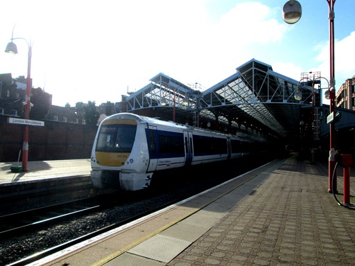
Marylebone Station, once the London terminus of the Great Central Railway, is now an important gateway to the Chilterns, to Birmingham and to Malvern Country. If you know where to look, you can still see traces of Marylebone's august Great Central past, a past that suffered under Beeching's notorious axe.
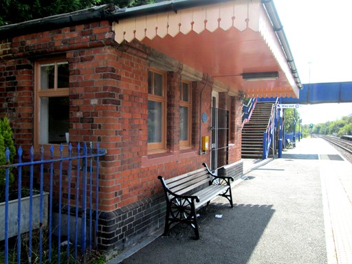
Saunderton Station still has its Great Central waiting room on the London platform - after Suffragettes burnt down the main station building in 1913.
The waiting room is under the aegis of the Friends of Saunderton Station and houses a small photographic exhibition which highlights the station's history. The waiting room, in its restored reincarnation, was officially re-opened by the local MP.
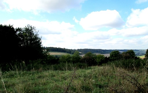
Chiltern Landscapes
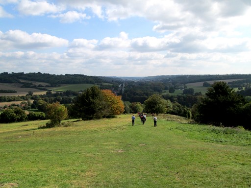
The Chilterns might appear to be predominantly a area of gently rolling hills, but they hide some quite steep gradients which provide the walker with nice exercise. Saunderton is a small village snuggly embedded in the north western reaches of the Chilterns. It is the centre for some interesting walks not too far from the Capital.
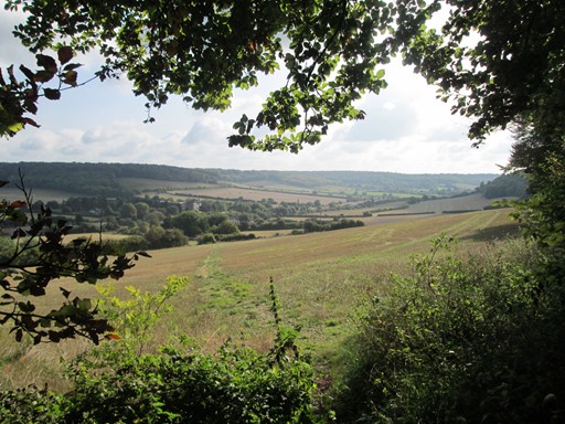
Having reached Saunderton on an earlier train, I explored a path to the north west of Saunderton and got this shot of the local countryside basking in the hazy sunshine of a sleepy Sunday morning.
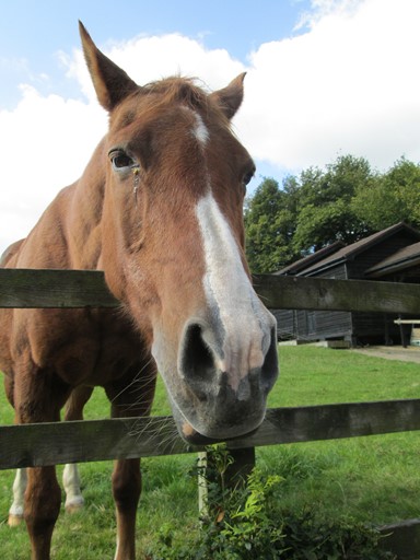
On the way along the ridge to West Wycombe we are greeted by this equine character
who lives at the local riding stables.
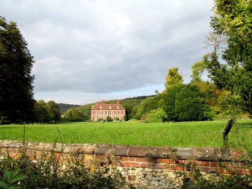
We have almost reached the promontory with St Lawrence's church, a promontory overlooking West Wycombe and West Wycombe House. Here is a view across the valley on the west side of the ridge on which we have walked from Saunderton.
St Lawrence's
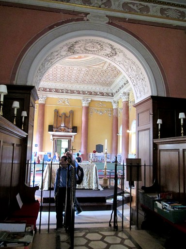
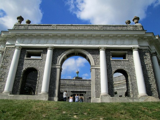
The wooded ridge past Nobel's Farm and through Hearnton Wood leads to the promontory, West Wycombe Hill, above the village of the same name. On this promontory sits Saint Lawrence's Church. While religious worship on this site goes back to at least the 7th Century AD, the present church is due to the wishes of Sir Francis Dashwood and was officially reopened in July 1763. It is Grade 1 listed and reflects the interest of Sir Dashwood in Classic and Italian art and architecture. The Dashwoods were the local landowning family who left their imprint on the surrounding landscape, as the subsequent section will reveal. We visited this church after Sunday service and the baroque music being played provided a fitting accompaniment to the 18th Century artistic splendor that greeted us.
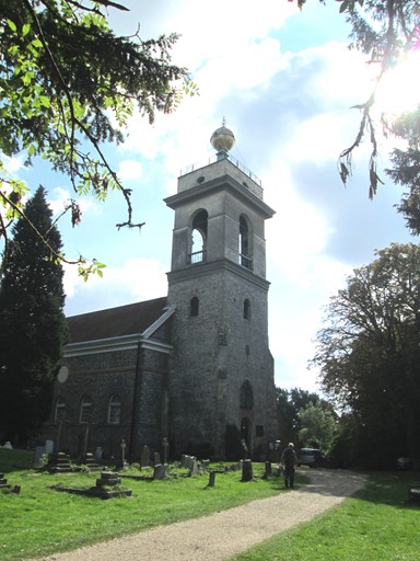
Approaching the church from the north, one already gets that Italian feel. The "campanile", with its open top is surmounted by a golden (gold leaf actually) ball, but without the usual cross.
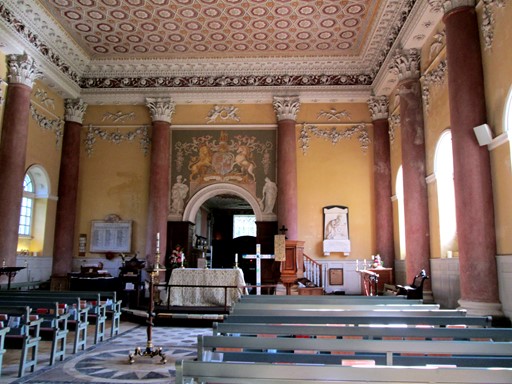
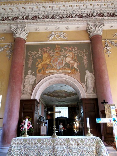
Within, the Classic influence is writ large.
The obligatory royal coat of arms (18th Century version) towers above the altar.
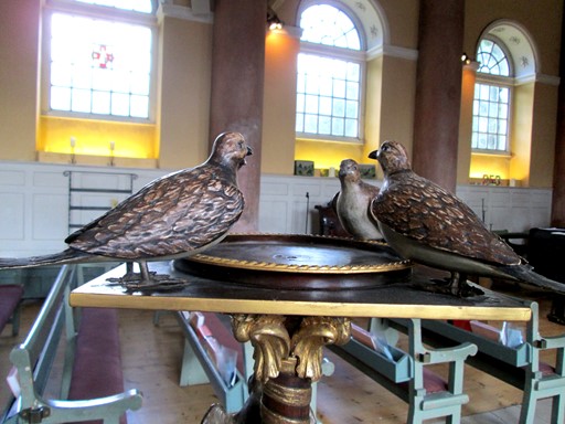
In the middle of the congregation, doves - actually four of them - surround what appears to be a candle stand. Space for a very large candle indeed!
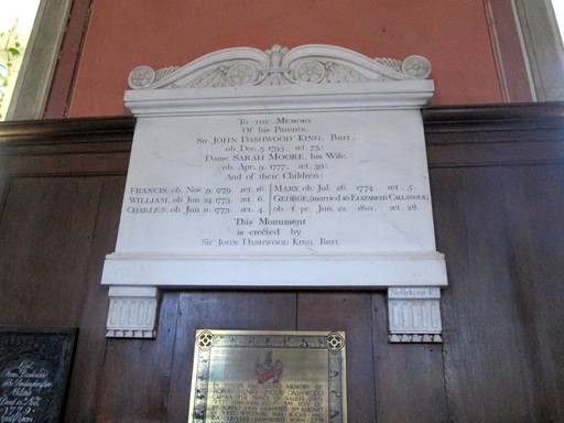
Church monuments give us an interesting glimpse into life and conditions in times past. Medical care, even for the rich, was certainly not up to what we would expect today. For example, I mean - people died young. If you reached your seventies, you were doing well!
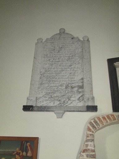
Now, this monument reads as follows.
"To the Memory Of his Parents
Sir John Dashwood King. Bart. died 3rd December 1793, age 73:
Dame Sarah Moore, his Wife, died 9th April 1777, age 39:
And of their Children:
Francis, died 9th November 1779, age 16
William, died24th June, age 6
Charles, died 11th June 1773, age 4
Mary died 26th July 1774 age 5
George (married to Elizabeth Callender) died 22nd June 1801, age 28."
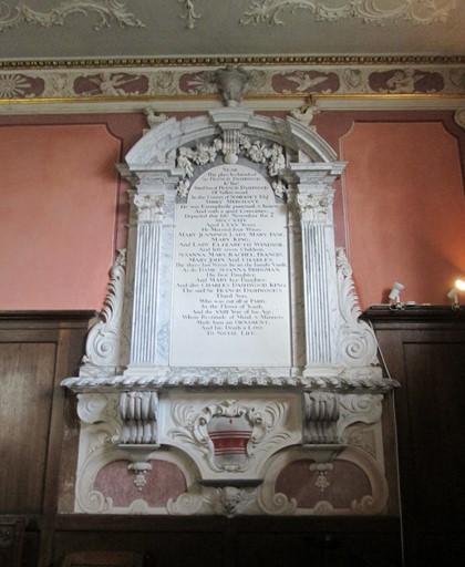
Here is another monument to yet more Dashwoods.
"Near this place lies intombed Sir Francis Dashwood Knight Baronet, third son of Francis Dashwood of Vallow-wood in the County of Somerset Esquire, "Turky" Merchant. He was exemplarily punctual and honest, and with a quiet conscience, departed this life 4th November 1724, aged 75 years. He married four wives ... ."
Further glimpses into history follow on the monument,
so reading them can be an interesting eye-opener for the curious!
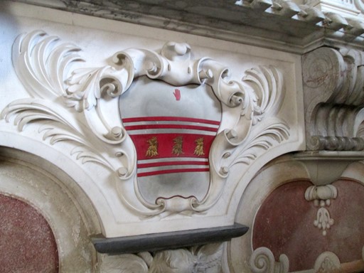
Of course, the Dashwoods have a very nice family crest.
The name goes back to the early middle ages, when it originally had the form "De Ashwood", reflecting the French influence on England at the time. 1066 and all that.
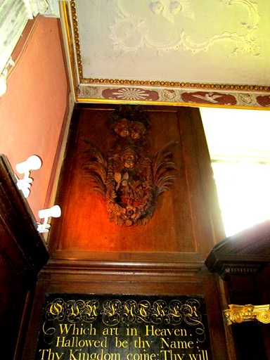
The high (second) altar is flanked on either side by ...
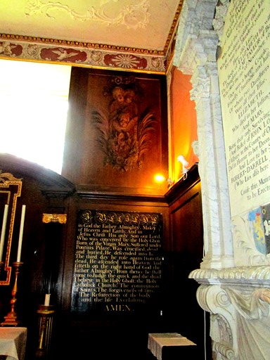
... splendid carvings - reminiscent of Grinling Gibbons, but post-dating him by at least 42 years.
Here's looking back to the church entrance ...
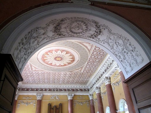
... at the same time, admiring the ceiling above the main congregation.
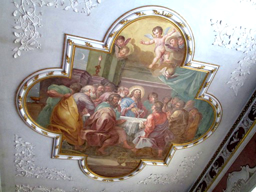
The ceiling between first and high altars is graced by a painting of the Last Supper.
Splendid indeed, I hear you art-lovers exclaim!
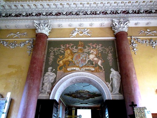
Here's another view of the royal coat of arms above the first altar.
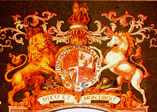
The detail of the coat of arms reveals the splendid colours.
Of course, here is the older, English and Welsh Standard with the French fleur-de-lys,
but before the latter was replaced by the Scottish lion.
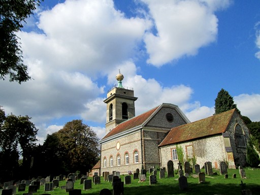
It's time to leave the church, whose exterior - a mixture of the Italian with a last remnant of the mediaeval - gives only a hint of the artistic splendours within.
The Dashwoods
The name of the land owning Dashwood family has become virtually synonymous with West Wycombe. Noble pile, noble church, noble mausoleum and Hell Fire Caves to boot. What more can a Buckinghamshire village wish for in terms of visitors and visitor income! We soak up the history oozing at every pore of the time-honoured buildings and monuments!
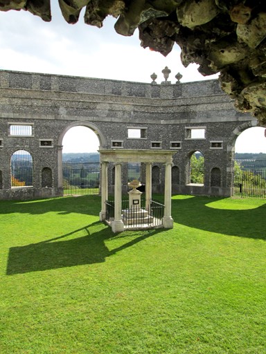
The Dashwood Mausoleum is close to Saint Lawrence's church and, with its stone sculptures, is an historical record of that family. Prominent families like to live on in stone long after their mortal remains have yielded to the inevitable.
The Mausoleum is shown off to good effect in the landscape by the wide sloping ground whose top it graces. From the mausoleum the path eventually narrows, and turns west past the caves which occupy the ground below the mausoleum. The caves have links to the "Hell Fire Club" - one of the affluent antics of erstwhile members of the Dashwood family.
Here is another view, looking back at the imposing hexagonal mausoleum. Very nice, some of these mausoleums - they can bring death to life!
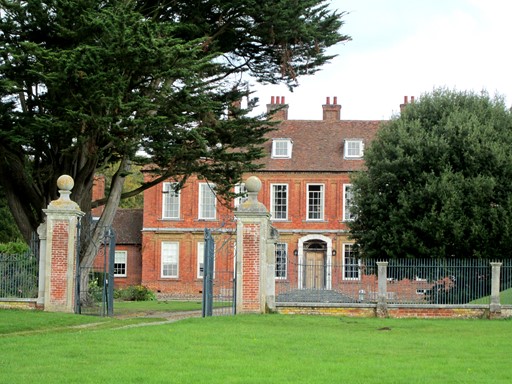
The Dashwood Mausoleum towers above West Wycombe House, a nice view of which we are about to take in on our right.
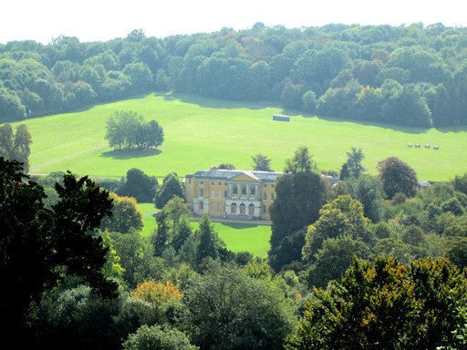
Although West Wycombe House, the ancestral home of the Dashwoods, was built in 1698 by Sir Francis Dashwood, it was extensively rebuilt by his like-named son. The historical significance of the house is that it has remained substantially unaltered since that time and thus is a fine example of country house style of the 18th Century. The house is open to visitors in July and August - so there could be a possibility for another visit.
West Wycombe
And so to West Wycombe itself, whose historical houses and pubs have stood up well to the ravages of history including the latest onslaught - that of the busy traffic passing along its high street. We have a choice of eateries and choose the "George and Dragon" for our lunch.
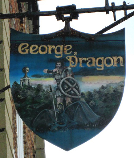
The "George & Dragon" was quite full be the time we arrived - one o'clock. However, the pub trade seemed to be very brisk - indicating that we had chosen a popular venue.
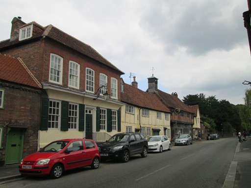
This is West Wycombe High Street looking east ...
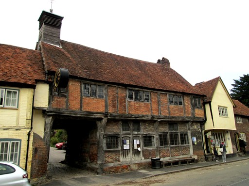
... and towards the timber-framed house through which Church Lane passes. This would be our route out of West Wycombe after a short sojourn in the tea shop bordering on, and to the right of, the said timber-framed house.
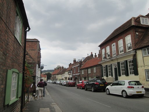
This is West Wycombe High Street - with its historical buildings - looking west towards the main entrance to West Wycombe House.
You can just make out the pub sign of the "George & Dragon" on the left.
Bradenham
Bradenham village is quite close to Saunderton Station, but some of us felt that it merited some of our time before we embarked on our respective homeward journeys. Bradenham is certainly a typical example of the once important local axis of power so often evident in English villages. The church and the manor house are indeed right next to each other and both face the village green - how rurally traditional can you get? A delve into local history proved to be time well spent!
Coming through the woods, Bradenham Manor hoves into view.
Bradenham Manor fronts on to the village green. In 1566 Queen Elizabeth I was entertained here. However, the present building dates mainly from the 17th century and later it was at one time home of the Victorian prime minister Benjamin Disraeli. Bradenham Manor now belongs to the National Trust who have turned it into "a nice little earner" by leasing it to a large commercial company. It appears that not all National Trust properties are open to the general public, if Bradenham Manor and the property in the middle of Lakeland's Derwent Water are anything to go by!
Hopefully, a few snippets of interest!
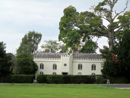
On the other side of the green is the 18th century "White House" complete with pointed windows and castellations. Who thought this one up?
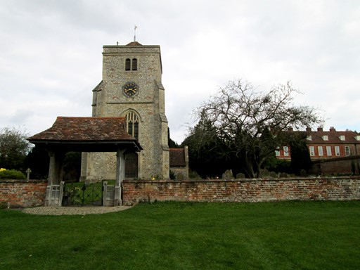
As so often in English villages, church and manor house are side by side. They formed an erstwhile axis of local power - the spiritual and the temporal. Between them, the church and the squire kept a watchful eye over their village community.
Part of the inscription on this monument inside the church reads as follows.
... "The remains of Sarah, wife of Charles Silard, of Winkfield in the County of Berks, are deposited in a vault underneath this tablet. She died August 27th, 1792, aged 39. To the memory of the best of wives, the most tender mother, and a sincere friend, ... . Likewise in the same vault are deposited the remains of the above Charles Silard ... ."
What were these people like? What was their view of the world?
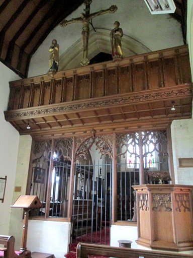
The church's history stretches back to Norman times, but the Victorians did not miss an opportunity to "restore" it, as the nice rood screen and pulpit clearly show.
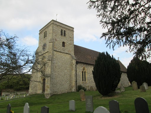
Here is one last look at Bradenham's church before we set off across the village green and the fields beyond to reach Saunderton Station. So ends a pleasant Sunday stroll.
Map & Heights
This was a gentle Sunday stroll of about 7⅓ miles or 12 kilometres. The gentleness of our stroll was emphasised by the total ascent which weighed in at a modest ¼ Kilometre. Overall, a nice, not unduly taxing, Sunday outing, with English history as its theme. For the numerically curious, I have added, in this section, some further items pertaining to our Sunday exertions. I hope you find these items interesting!
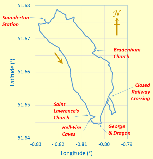
Saunderton Station was the start of our "circular" walk
which, at its southern extremity, took in "Dashwood" country.
The map grid scales translate to 2.76 Km per 0.04° longitude and 4.45 Km per 0.04° latitude,
or, if you prefer, 0.690 Km per 0.01° longitude and 1.112 Km per 0.01° latitude,
all when using 6371.0 Km as the volumetric mean radius of the earth!
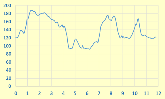
The ups and downs on this graph show you the heights we reached on our walk.
The vertical (y-axis) scale is in metres and the horizontal (x-axis) scale is in Kilometres.
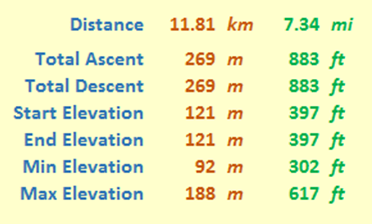
These might at first glance look like a mass of numbers. However, it's what we can read into them that I think is quite interesting. For example, our total ascent was just over a modest ¼ of a Kilometre, and the total mileage (as always, measured on a conceptual flat plane) was about 7⅓ miles. As expected, total ascent and descent are the same, and start and end elevations are also equal to each other - as indeed they should be for a circular walk!
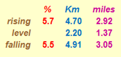
And here, for the numerical fun of it, are the gradients we overcame on our walk. Each gradient is averaged over the distance given, with level stretches having rises less than ± ½ metre. By comparison, Hertfordshire County Council recommends that its roads should not have longitudinal gradients of more than 5% and one of the steepest adhesion railways in the world, in Austria, has a maximum gradient of 11.6%.
Thank You!
Many Thanks to Owen Simon who organised this walk at short notice in response to unexpected engineering works on the Metropolitan Line. Thanks also to Owen, having devised this walk, for duly leading it without undue hesitation or, indeed, without too much deviation! Of course, also thanks to all for your company. Thanks also to the "Weather Gods" who smiled benignly on us all day!
For Next Time
The area around Saunderton certainly merits further visits, not only to enjoy more of the pleasant countryside, but also to catch the seasonal changes - for example, autumn with its rich golden tints could be a particularly attractive time to visit. Bledlow, with its woods, and Great Hampden, with its woods and its interesting House and Church, are villages that could both feature on a walker's agenda. On the cultural front, West Wycombe House and Hellfire Caves could be part of a visit, as could Hughenden Manor, not too far away on the outskirts of High Wycombe. The "Icknield Line" is also close by, and a trip thereon could easily be incorporated into a walk. This is an area waiting to be explored!
Contact, Copyright & Please Read Me!
Please click here for more general logistical and copyright considerations relating to this page and other pages on this web site. Thank you!
Eric Scharf
Latest Version: 2014-09-26 @12:53
Updated: 2016-01-29 @13:27
SAGAX REX HANC RETIS ORBIS PAGINAM PINXIT ANNO MMXIV ET MMXVI.
© Eric Scharf 2014 and 2016