 |
WENDOVER CIRCULAR 2015 - June - 14 |
|

What you will see here
This was a nice country walk, not too taxing on the constitution, but ably led by Tim. We had nice walking weather - no rain, and not too hot. The Chiltern arm of the Grand Union Canal, Wendover Woods, and Aston Hill of Aston Martin fame, were all on our leisurely walking agenda this Sunday. "The Bell" at Aston Clinton and the "Chocolatier" tea shop were on our gastronomical agenda. A pleasant day was had by all.
We have just scaled Aston Hill of Aston Martin automobile fame.
At 260 metres, this was almost the highest point of our walk.
The nearby Wendover Woods would take us slightly higher still, to about 272 metres.
First of all, I hope you are not averse to a bit of playful verse. Admittedly, you are probably more accomplished poets than I! However, it seemed nice to sum up our experiences before we dive into the pictures and some, possibly quite interesting, facts and figures.
|
This Sunday to Wendover we went, and 'twas time really well spent. Part of the Grand Union Canal we explored and the late Spring countryside we adored. It was a colourful bridge that we saw. A nice tribute to the Rothschilds of yore. Past a remote airfield we then walked and of the RAF and gliders we talked. And so to Aston Clinton's "The Bell", where we of a nice lunch all could tell. In the afternoon up Aston Hill we did progress, scene of Aston Martin's motoring success. Wendover Woods were next on our way. with nice Chiltern views on display. In Wendover 'tis time for tea and cake ere we our homeward journeys make. Tim indeed we thank you by name for this fine walk on which we came. |
So here's what you will see on this page. If you joined us on our walk, I hope this page will bring back some memories of this pleasant Sunday. If you were not fortunate enough to join us, then I hope you will at least get some flavour of what this neck of the Chilterns has to offer. I wish you happy perusing!
- Coming to Wendover
- Our Canal Walk
- Lunch in Aston Clinton
- Aston Hill & Wendover Woods
- Features of Our Walk
- Postscript
- Contact, Copyright & "Readme"
Please click here for more general considerations relating to this page and other pages on this web site.
Coming to Wendover
Departing from Marylebone Station is usually a nice experience, and today is no exception. It's a well kept station serving the affluent Chilterns. The only thing is that it is sometimes a bit challenging to get to Marylebone Station in the first place. With a journey time of only about 50 minutes, it is the quickest way to the start of our walk. Even so there is a wait of about 40 minutes before the train departs. However, this allows time for a "wake-me-up cafe latte" at a nearby Costa's, accompanied - of course - with a welcoming chat with "IVCers" about all sorts of things. Thanks Adrian for the idea and the coffee! And there's also time to appreciate the vestiges of the golden age of the Great Central, as these next three pictures proudly testify. There's so much to do whilst waiting for the train!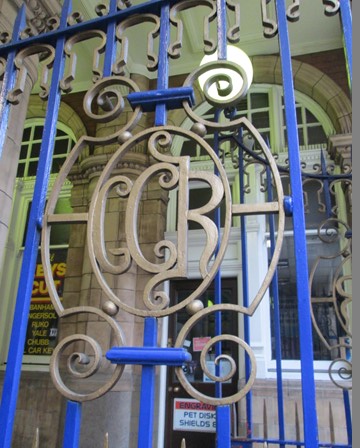
The station gates proudly proclaim that this is Great Central territory. The Great Central main line to Sheffield was expunged out of existence by Beeching, but HS2 - which follows a fair bit of the old route - is now firmly on the agenda. Is there a proverbial moral lurking somewhere?
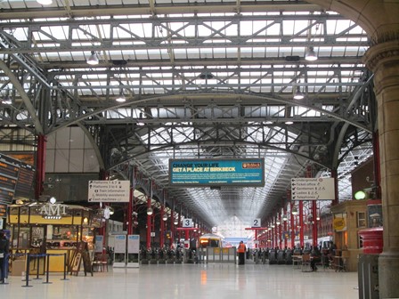
Trains depart from Marylebone for the suburban destinations of the old Great Central including Gerrards Cross, Aylesbury and Princes Risborough. To this list have been added places further afield ... places such as Birmingham, Kidderminster and Malvern. Marylebone Station has certainly found a busy new life after Beeching.

Having arrived at Wendover Station we see a lovely bit of Victoriana. Metropolitan Railway, methinks. Look upwards ... and sometimes ye may find artistic splendour!
Our Canal Walk
From the station it's a mere stone's throw to Wendover's pretty High Street. The Wendover branch of the Grand Union Canal (the "M1" of the early 1800s) is close by. The canal banks are full of the verdant ebullience of a Chiltern summer. After Halton, a decorative bridge over the canal reminds us that the Rothchilds had many associations with this part of the county. We then leave the canal, and after passing a sleepy airfield, reach Aston Clinton for our lunch stop.
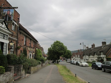
Wendover's traditional High Street greets us before we turn off to reach the Wendover branch of the Grand Union Canal.
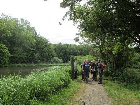
The Grand Union was the busy "M1" of its day, but this branch of it exudes the peace and tranquillity of a late Spring afternoon. We tarry awhile to read the notice telling us a few more historical facts which we did not know before.
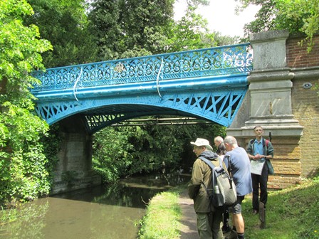
Oh, what a lovely bridge. This bridge over the canal - as Tim explains - celibrates the strong connection between this part of the Chilterns and the successful Rothschild clan.
Indeed, at our lunch time stop, we shall see a picture showing the 43 properties the Rothschilds had in this area - yes, 43 houses! The bridge itself was built around 1880 to link the two parts of the Halton House Estate, separated by the canal. Bachelor Baron Alfred de Rothschild used to surprise the boatmen on the canal by crossing the bridge in his carriage drawn by a zebra.
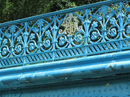
Indeed, the details of the intricate parapet tell us a bit more about the Rothchilds. For example, we can see the five arrows indicating the five branches of the Rothschilds - Germany, Austria, England, France and Naples (then still an independent state). In the middle of each parapet is a gold Rothschild monogram, made up of a jumble (in the way of monograms) of elegant letters.
Lunch in Aston Clinton
Aston Clinton lies on a Roman Road, which, as Roman Roads tend to do, has got a bit wobbly over the centuries. However, we look out for "The Bell" with its appropriate inn sign - a large, but probably non-functioning, bell, no less. "The Bell" has a food hygiene rating of 5 out of 5, as expected round these affluent parts. The food is nice, albeit with prices also tending to reflect the affluence of the area. As we savour our respective repasts, we also have the opportunity to admire the restrained decor and ornaments which look down upon the dining guests.
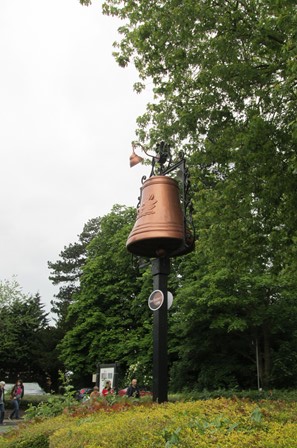
The bell on Aston-Clinton's main (Roman) road makes sure that travellers know that "The Bell" is there, even if slightly hidden from the said road. Can't miss it - the Bell that is.
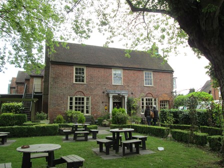
It's still a tad early which means that we get served reasonably soon.
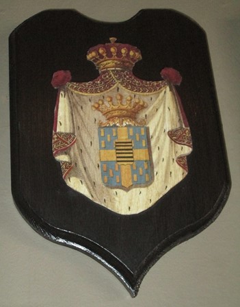
Above the fireplace by our table there are six interesting crests, of which this is one. This might be connected with the Rothschilds, for each quarter of the crest has five identical objects of some description. Anyway, after our respective repasts, we are now ready to rise to higher things - our afternoon ascent of Aston Hill.
Before we go, just another look at that splendid crest!
Aston Hill & Wendover Woods
In the afternoon we rise to higher ground, scaling Aston Hill, and enjoying the nearby Wendover Woods. Between 1904 and 1925, Aston hill was a sort of proving ground for a novel technology of the time - the motor car and its racing derivatives. Mr Martin built very good cars which out-performed those of his contempories. The "Aston Martin" brand was born! On Aston Hill we reach a triangulation point, which at 260 metres, matches the height of its friend on nearby Coombe Hill (the one with the Boer War monument). Then we enter Wendover Woods and pass somewhere near the highest point (about 272 metres A.S.L.) in the Chilterns. After this, we descend to Wendover and enjoy tea and cakes at the "Chocolatier" in the High Street. We are suitably refreshed as we then head back south on the Chiltern Line. A nice day! Thanks everyone!
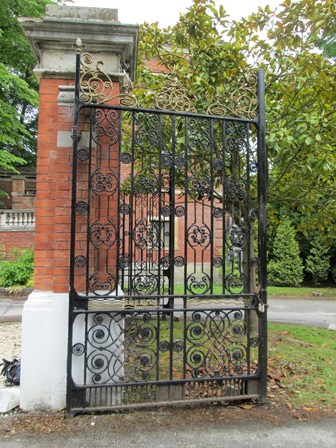
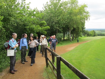
On the way to Aston Hill, we pass some ornate gates leading to Green Park, whose buildings appear to serve a variety of community purposes.
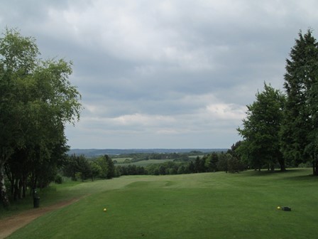
On we go up the side of a golf course offering distant views towards the Vale of Aylesbury.
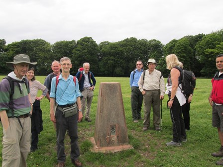
Here we stop to pose for a group photo and to enjoy the said view.
We have not actually reached the highest point of our walk, which is buried in the nearby Wendover Woods. However, at 260 metres, this triangulation point matches the height of Coombe Hill (the one with the monument). The triangulation points of the Ordnance Survey hark back to the 1930s way of producing maps. It's all airborne photogrammetry now.

As we return to Wendover, this nice view across to
Coombe Hill (the one with the monument) greets us.
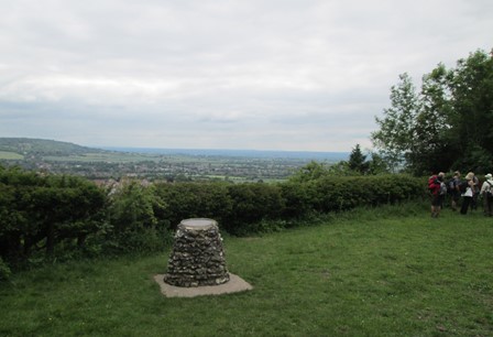
We stop awhile to enjoy the view, and then see what more there is to be seen, with the help of this ellipsoidal source of knowledge set firmly in its stone plinth.
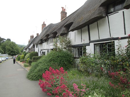
On the way into Wendover we are greeted by this row of cottages with colourful front gardens.
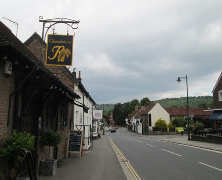
The "Chocolatier" tea shop in High Street Wendover is our final port of call. Tea and cakes and a natter before we head for home. It's been another nice IVC day.
Features of Our Walk
For our circular Sunday walk, using map plotting, I estimated the distance to be 9.2 miles or 17.7 km. This is a little less than the 9.4 miles measured by Tim, but what's in a difference of 0.2 miles? Not too much really!
For the first half of the walk, from Wendover to Aston Clinton, we largely follow a branch of the Grand Union Canal. It's all on a low level. However, in the afternoon, we rise to higher things, reaching all of 260 metres on Aston Hill and higher yet in the Wendover Woods, through which we descend to Wendover itself. Not unduly taxing on the constitution, but very pleasant and relaxing.
Now prepare ye for some plots and graphs. Not too overwhelming, but hopefully quite interesting! You will see here:
- An Outline Map of Our Walk
- Height Profile of Our Walk
- Some Facts and Figures
- Average Rising and Falling Gradients
Outline Map of Our Walk
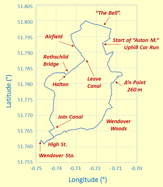
Outline Map of Our Clockwise Circular Walk
The minus signs for the longitude angles indicate "degrees west of Greenwich". The map grid scales translate to 0.690 Km per 0.01° longitude and 1.112 Km per 0.01° latitude, all when using 6371.0 Km as the volumetric mean radius of the earth! Top is North by time-honoured convention!
Height Profile of Our Walk
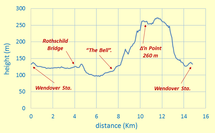
Height Profile
This height profile shows that in the morning we were at times below the water level of the canal - sounds sort of Dutch! The height profile also clearly shows the higher ground we scaled after lunch. We reached the highest point of our walk somewhere in the Wendover Woods after our group picture at the 260 metre OS triangulation point. Indeed, somewhere in the Wendover Woods is the highest point in the Chilterns, but where exactly I have never found out - probably a well-kept local secret!
Some Facts and Figures
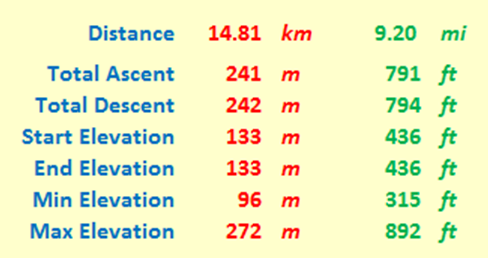
"Walk facts and figures"
Here are some "vital statistics" in metric and imperial units. Of course, the total ascent (here 241 m) usually exceeds the difference between maximum and minimum elevations (here (272-96) m or 176 m); I'd suspect things, if the reverse transpired! Start and end elevations are the same (133 m). Total ascent and total descent should also be the same, but my plotting is not perfect, producing results (241 m and 242 m) that should be seen as being of an indicative nature! The total distance, as always measured on a conceptual "flat" plane at mean sea level, was 14.81 Km or 9.20 miles. As already mentioned above, the total ascent was about 0.241 Km or 791 feet.
Average Rising and Falling Gradients
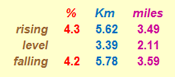
Rising and Falling Gradients
And here, for the numerical fun of it, are the average gradients we overcame on our walk. The rising and falling (negative) gradient are both averaged over the distance given, with level stretches having rises less than ± ½ metre. By comparison, Hertfordshire County Council recommends that its roads should not have longitudinal gradients of more than 5% and one of the steepest adhesion railways in the world, in Austria, has a maximum gradient of 11.6%. By way of further interest, the clockwise route of the Fairfield Horseshoe in the Lake District has a total distance of 15.62 Km (9.71 miles), with the following calculations: an average rising gradient of 14.66% over 6.589 Km, a level part over 0.345 Km, and an average falling gradient of 11.11% over 8.676 Km. This is seen by many as quite challenging!
Postscript
Thank you Tim for organising and leading this walk. Tim, you said you had actually led this walk about a decade ago, but today you certainly led it without hesitation or deviation! Thank you all for your good company. It certainly has been a nice and successful day out - lots of nice countryside and good exercise. A rewarding way to spend Sunday!
Eric Scharf
Original: 2015-06-15 @20:31
Updated: 2015-06-16 @21:11 and 2015-10-03 @19:12
SAGAX REX HANC RETIS ORBIS PAGINAM PINXIT ANNO MMXV.
© Eric Scharf 2015