 |
EPSOM to BOX HILL 23rd February 2013 |
|
| OUR WALK LANDSCAPE HEADLEY BOX HILL THANK YOU MAPPING FEEDBACK READ ME |
Our Walk
Our walk of almost twelve miles - or was it 10.5 miles? - was ably led by Nick, who found the way on "auto-pilot". We started in Epsom, just out of the reach of Boris's Transport for London, and enjoyed the opportunity to get some good exercise in these cold winter months. The temperature was only a degree or so above freezing and there were a few gentle wisps of snow, but we soon got warmed up. Our exercise was complemented by some nice views in most directions and a bit of a delve into British history.
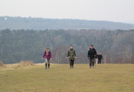
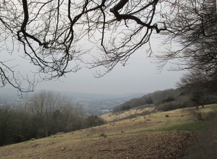
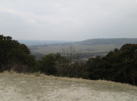
On the stretch from Headley to Box Hill, we advance boldly, taking Juniper Top by storm.
I have divided the description of our walk into the following sections and I have also added a link to a hopefully useful "Read-me" page.
- Landscape Features of Our Route
- Epsom to Headley
- Headley to Box Hill
- Thank You
- Mapping our Route
- Thank you for your Comments!
- Spoken Narrative.
This is a quick one minute audio presentation of our walk. This audio clip should work with the three main browsers, but please click here if you would like more logistical details on this audio presentation.
- Contact, Copyright & "Readme"
Please click here for more general considerations relating to this page and other pages on this web site.
Landscape Features of Our Route
We started our walk in the former spa town of Epsom, and after escaping the hectic Saturday morning activity, soon reached Lord Roseberry's former mansion. Epsom Racecourse and Epsom Downs were next on our agenda. Then it was "cross-country" to Headley. There were studs and horses everywhere - as befits the countryside around Epsom. Headley's landmark was a rather gaunt looking Victorian church, but the pub next door gave us a good warm-up. Then it was more "cross-country" to the National Trust land of Box Hill. Here we had a steep climb to Juniper Top, and were rewarded with distant views. We stayed more-or-less on the level as far as the Box Hill monument and viewpoint. Then, after a reasonably quick but scenic descent and a visit to the Bikers' Cafe (hygiene rating at an excellent 5) we eventually reached Box Hill & West Humble Station for the journey back to the Metropolis.
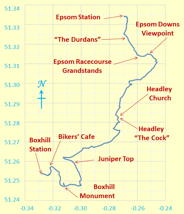
Our route was roughly north to south,
but we meandered a tad to absorb contours and points of interest.
Degrees Latitude and Longitude feature on the Y and X axes respectively.
Regarding distance, Nick's estimates are - and I quote him - as follows.
"4 miles from Headley to Box Hill viewpoint, which took us 2 hours (more ups and downs and subsequent stops).
"1.5 miles from Box Hill to Westhumble, which took 30 minutes to the cafe and 15 minutes to the station.
"At least we kept on schedule without having to rush ...!"
Ups and downs characterised our walk, as one would expect on the North Downs. Start and end points were at about 165 and 177 feet above mean sea level respectively, and formed a sort of base line. The highest point was at about 668 feet in the Box Hill massif, between Juniper Top and the Box Hill Memorial viewpoint. Most climbs and descents were quite gentle, except for the concentrated steep climb of about 300 feet to reach Juniper Top. All in all, typical undulating North Downs country!
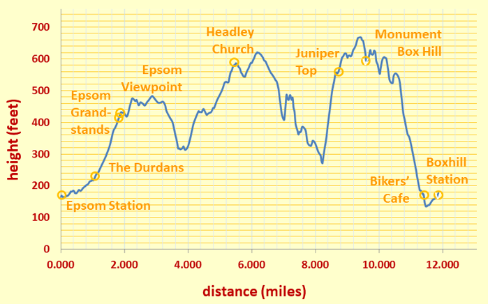
We started off at 165 feet in busy Epsom and reached a maximum of about 668 feet on the Box Hill massif. The yellow circles mark the way points named here. Good exercise and fresh air!
Now that you have an idea about the route, the history and the terrain, it's time to gather some visual impressions. Although the sun was hiding somewhat, I hope these pictures will give you some nice views of our walk.
Epsom to Headley
It was good that the start of the walk was not a bad omen for the rest of the day! So what did we experience?
Well, Epsom station seems to have been recently modernised with its entrance hall built into a block of flats of unflattering appearance; the station entrance hall exudes a tiled monotony reminiscent of a super-loo - perhaps something to do with the medicinal use for Epsom Salts for which Epsom is famous(?). (Incidentally, a housing estate now covers the site of the original springs!) However, all is not lost, for Epsom still has some nice traditional buildings.
Horses and stud farms are very much the flavour all the way to Headley. Lord Roseberry, who owned "The Durdans", had a winning horse at the Derby. The Derby,
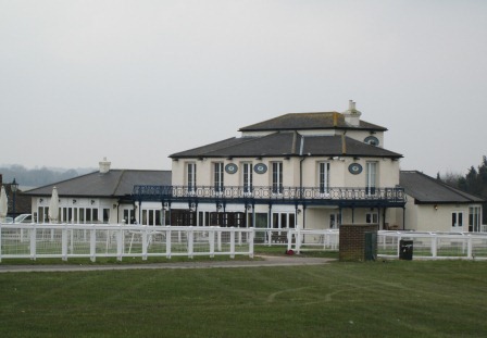
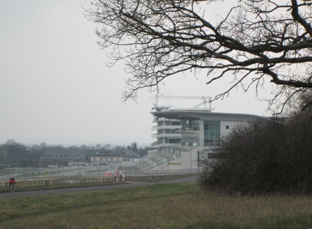
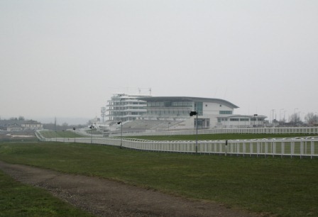
named after the 12th Earl of Derby, is of course still held nearby at the Epsom Racecourse. Epsom Racecourse is very quiet today, but its associated buildings, old and modern, testify to the busy race meetings that are held annually and attract royalty. The Epsom Downs are adjacent to the racecourse and have a viewpoint from which we can look towards central London.
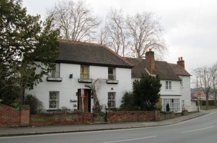
Despite some architectural upheavals in the town centre, Epsom still has some traditional houses. This one has a "For Sale" notice, but hopefully will not be pulled down.
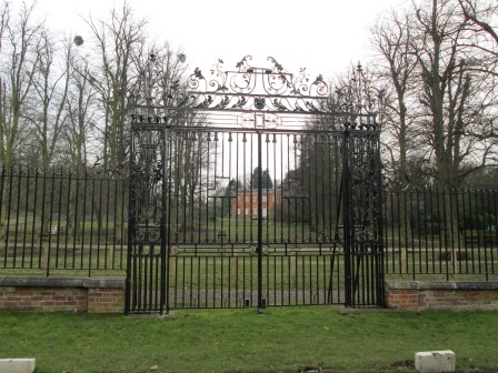
Lord Roseberry had three aims in life - to marry an heiress, to win at the Derby and to become prime minister - all of which he achieved before reaching 50, but then, no doubt, he had a good start in life even before embarking on his life's quests. In 1874 he bought "The Durdans", one of whose splendid wrought iron gates you see here guarding the red-brick mansion beyond. He became prime minister in 1894. The house and estate have since changed hands, and a lot of the grounds have succumbed to the need for housing.
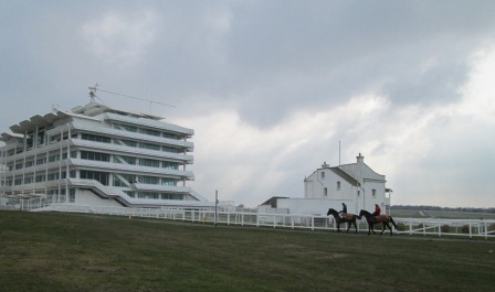
Racing is not scheduled today, but these two riders are out for some equestrian exercise, overshadowed by one of the two massive spectator stands on the left. Despite the tradition and prestige surrounding the Epsom Derby, this stand does look rather "concretey" and "new build"!
Now for something more traditional. The "Rubbing Horse" (yes "bb" and not "nn") Inn is right on the edge of the race course and - as its name implies - used to be the place where horses were rubbed down after each race. After a few fires and rebuilds, this Victorian building has changed its calling in life; it now caters for human gastronomical needs as opposed to the well-being of the equine population.
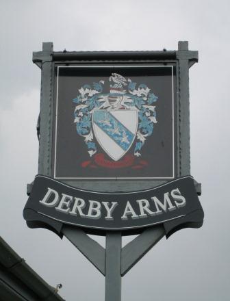
The 12th Earl of Derby, who left us in 1834, was regarded as the founder of horse racing - hence, of course, the use of the word "derby" for the sport and for down-market manifestations such as the "donkey derby". This sign graces another Victorian watering hole, built close to the race course to attract business from the punters.
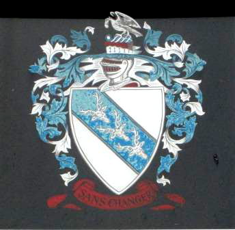
Here is a close-up of the somewhat weathered sign. Three golden bucks' heads grace the centre of the crest and the motto seems to express a wish by the Earl of Derby to live in an unchanging world.
The Epsom Downs border onto the racecourse, and we spend some time checking out the panoramic view of London from the south west.
It was a tad misty today, but we picked out some landmarks.
Proceeding on our walk we got another view of the two main Epsom grandstands over shadowing the "Rubbing Horse" gastro-pub ...
... and here we see our three friends again, nestling in the wide open expanse of Epsom racecourse.
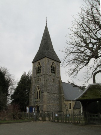
And so we reach Headley, whose original Norman church fell prey to the Victorian "restoration" zeal in the 1850s.
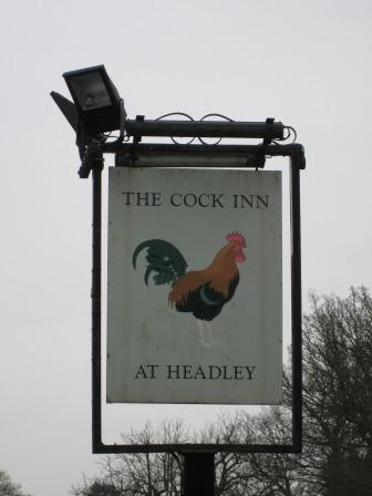
In many villages the two aspects spiritual - the divine and the earthly - sit side by side. And so it is in Headley where the "Cock Inn" has been positioned right up by the church. The fare at the "Cock Inn" warms the cockles of our hearts - gastronomically speaking.
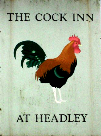
The poor cockerell is trying his best to welcome visitors from his position on a rather weathered and gloomy inn sign. Despite the sad-looking inn sign, prices at the inn don't allow the customer to forget the affluence of the area.
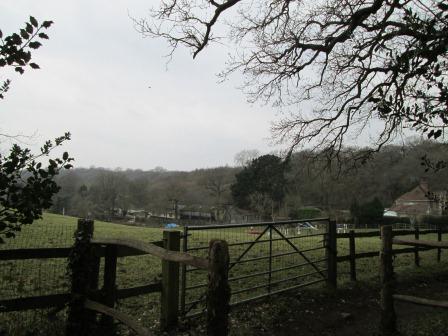
Headley is embedded in the undulations of a typical North Downs landscape.
Headley to Box Hill
On this half of the walk we are definitely getting further from the tentacles of the Capital and into the "Surrey Outback". There are many wooded paths and descents and climbs, including the 300ft rise to Juniper top, the gateway to the Box Hill massif. Why Box? Well, there are lots of Box trees on that massif. Box is a hard wood that apparently does not float! Remember your first - wooden - school ruler? Not the one you got slapped with. Enough of looking back to your formative years, we have some more nice views ahead. So enjoy the present!
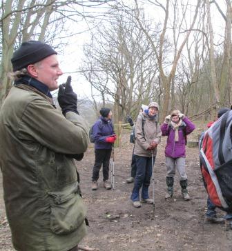
Since we are getting into the Surrey wilderness, our walk leader deems - a short way out of Headley - that now is the time to do a person count. We don't want anyone to get lost.
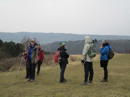
We have scaled the steep 300 foot climb to Juniper Top. The slope looked more like a red ski slope than your weekend walk.
Some more of our party advance boldly, taking Juniper Top by storm.
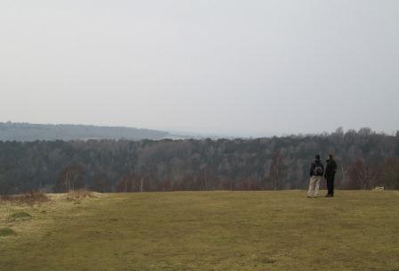
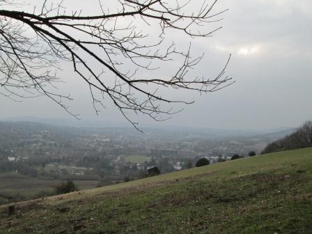
One can see Windsor Castle from here, but today's conditions put a bit of a damper on our expectations.
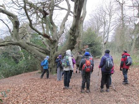
After Juniper Top we strike into the woods where no one has swept up the autumn leaves. A curious interwined sort of tree grabs our collective attention ...
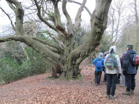
... for quite a few minutes.
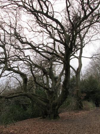
What a tree! The "twirlings" fly out in all directions.
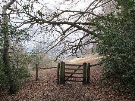
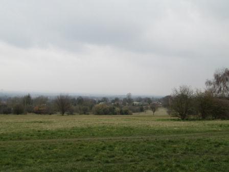
A gate, nestling in the autumn leaves, leads to an interesting south-facing view point ...
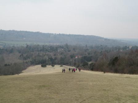
... of which we see more in a few seconds. This looks nice, although it is not the main Box Hill viewpoint, which is still to come after about 15 minutes or so.
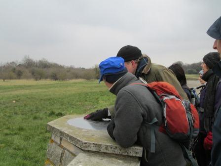
This is the main Box Hill viewpoint where it is possible to see as far as Devil's Dyke and as close as Leith Hill tower. It's the main viewpoint because there are quite a few visitors around who seem to have parked their cars by the nearby Visitor Centre.
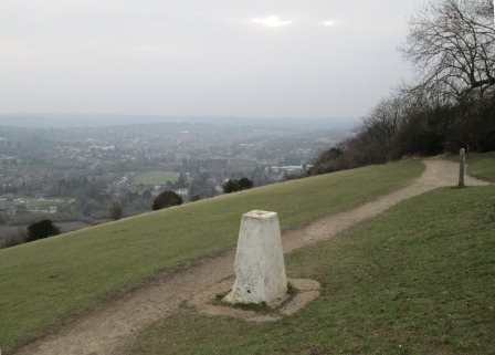
The monument or memorial at this viewpoint is not that photogenic, but it enables me to position myself for this shot of what the OS is interested in - the triangulation point in the "triangulatable" landscape. Without which, no maps - at least not the ones we know and love.
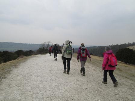
And so we set off on our chalky descent ...
... soaking up our last views on our way.
We are almost at valley bottom. The Bikers' Cafe (hygiene rating 5 - excellent) awaits before we head for Boxhill and West Humble railway station, which looks much nicer than the one at Epsom.
Thank You
What a nice invigorating winter walk! Thanks be to Nick for steering us all on auto-pilot through some of the attractive countryside on London's doorstep. It will be an interesting challenge to repeat the walk, armed with a GPS, to check the distance. Is it 10.5 miles, or is it 12 miles? But what's in a difference of 1.5 miles? A great time was had by all, and of course, we all look forward to more of the same - or at least very similar.
Mapping the Route
H
ere are the files, named "epsombox" with the appropriate extension, each of the first three of which,
".gpx",
".kml", and
".tcx",
can be put into an appropriate GPS system or uploaded to the following web site:
http://www.bikehike.co.uk for viewing (superimposed on an OS or Google map) and for analysis.
The ".txt"
file, while not "uploadable", is, nevertheless, useful for making pretty distance and height plots of your route - just use the earth's mean radius if you want actual, as opposed to relative, distances at mean sea level!
For the appropriate file (
".gpx",
".kml",
".tcx",
".txt"
) do a "right mouse click" and then click on "Save Target As" to save the file in your chosen directory on your machine. You may need to wait just a few seconds for things to happen.
In the context of these mapping files, please do not forget the disclaimer regarding any use you might wish to make of the content on, or available via, this web site. Thankyou!
Thank you for your Comments!
Your comments are always appreciated! It's always nice to know that my endeavours - modest though they may be - do not go unnoticed! Importantly, of course, you urge me to greater efforts on behalf of CLOG! Again,
Many Thanks for your comments, and of course, also for your company on the walk if you were fortunate enough to join us!
Eric
Post Scriptum: I have not put the names to your individual comments which you will see below.
"I was on the walk last Saturday and just wanted to thank you very much for the lovely photos and report of the day which you have sent."
CLOG Member, February 25
- o -
"Thank you, Eric."
CLOG Member, February 25
- o -
"Thanks for that link Eric. The trace of the route is particularly useful as it was a lovely walk which I'd like to try myself - one day when I'm brave!"
CLOG Member, February 25
- o -
"Thank you so much. This must have taken ages to put together."
CLOG Member, February 26
- o -
"... and not forgetting that I, too, am appreciative of the photos and narrative !"
CLOG Member, February 27
Eric Scharf
Original: 2013-02-25 @22:10; Updated: 2013-02-26 @23:57 and 2013-02-28 @11:45
SAGAX REX HANC RETIS ORBIS PAGINAM PINXIT ANNO MMXIII.
© Eric Scharf 2013